Tag Archives: Maps

A Human-Level Intelligence at Antietam

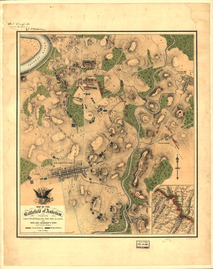
“Map of the battlefield of Antietam,” by William H. Willcox. Published in Philadelphia. Lithograph of P. S. Duval and Son, 1862. From the US Library of Congress.

There are many reasons that I am intensely interested in this particular American Civil War battle fought on less than twenty square miles wedged in between the Potomac River and Antietam Creek. The battle of Antietam (September 17, 1862) exhibits a number of significant battlefield attributes which I use as base line cases to test algorithms used in creating a human-level tactical artificial intelligence 1)MATE: Machine Analysis of Tactical Environments. Specifically, Antietam definitively demonstrates 2)see http://riverviewai.com/download/SidranThesis.pdf the following attributes:

  • Choke Points
  • Anchored Flank
  • Interior lines of communication
  • Exterior lines of communication
  • Restricted Avenue of Retreat
  • Restricted Avenues of Attack

For example, in a blind survey of Subject Matter Experts (SMEs), it was overwhelmingly agreed that the RED (Confederate) left flank at the battle of Antietam exhibited the attribute of ‘anchored flank3)a flank that is attached to or protected by terrain, a body of water, or defended fortifications. and other positions, such as RED’s (Russian and Austrian) left flank at Austerlitz SMEs overwhelmingly agreed that the flanks do not exhibit the attribute of ‘anchored’ and are, therefore, unanchored. Once we have an example of an anchored flank and another example of an unanchored flank we can begin testing algorithms to detect the attribute of an anchored flank.
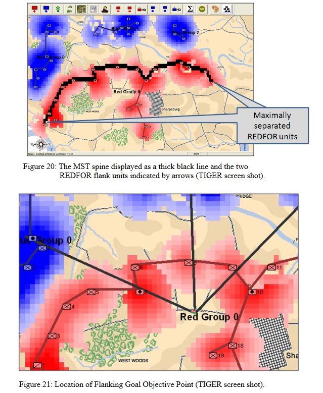
In my doctoral thesis (above) I demonstrated the algorithm 4)see pages 45-6 http://riverviewai.com/download/SidranThesis.pdf  for detecting the attribute of anchored and unanchored flanks. I have made a number of substantial improvements to the original algorithm since then which are now incorporated into the current MATE.

We have recently posted analyses of other battles that did not exhibit the attribute of an anchored flank (Ligny and 1st Bull Run, or Manassas). MATE correctly recognized that Ligny and Manassas do not have these attributes.

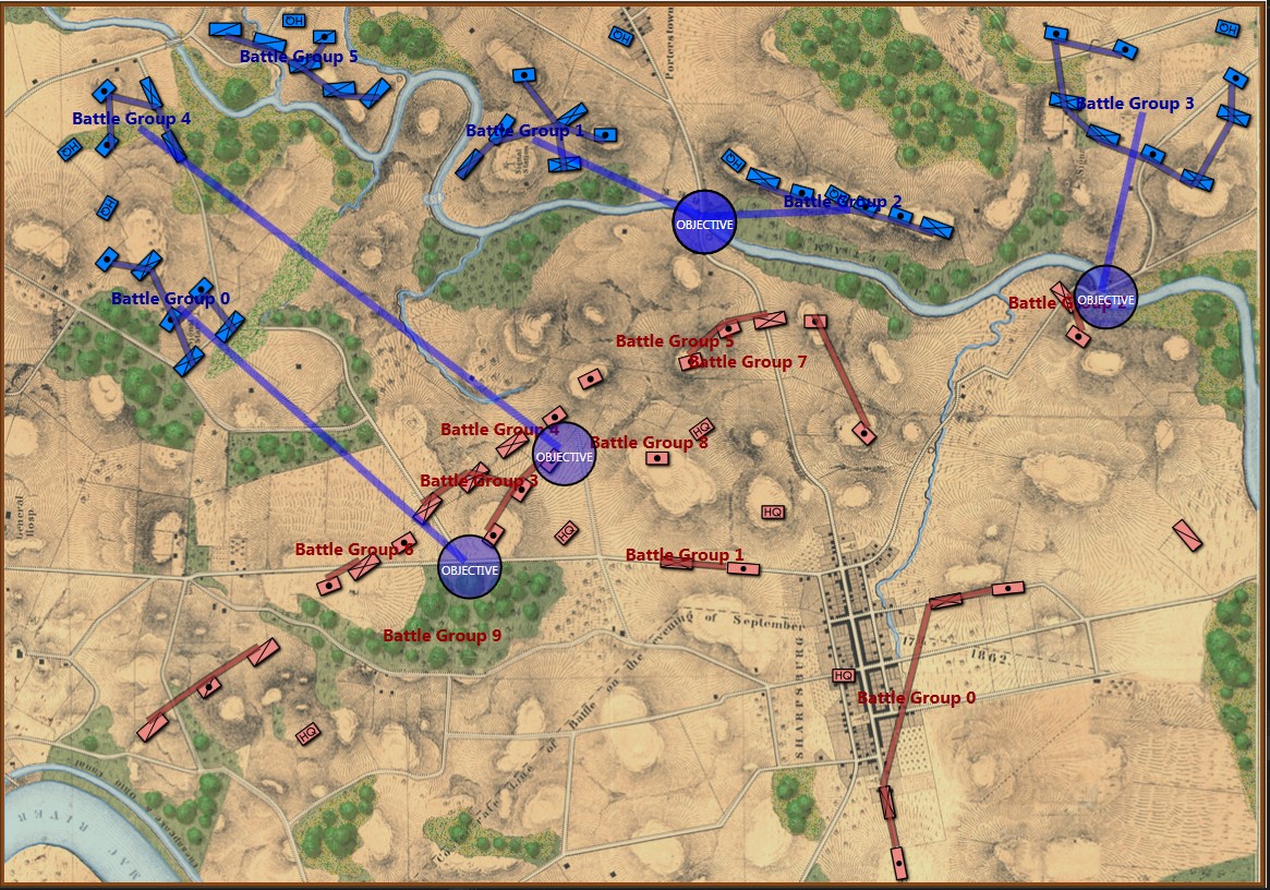
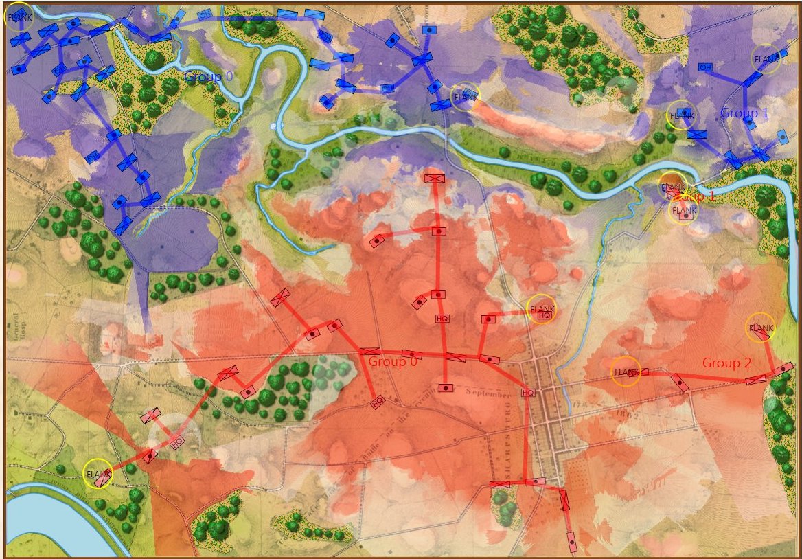
The tactical situation for Blue at Antietam is quite different than Blue’s positions at Ligny and Manassas (is it not curious how often Blue is the attacker in wargames?). The key difference, of course, is the lack of an open flank to attack. MATE will always attack an open flank if it can. Without an obvious objective, like an exposed flank, MATE will next look at opportunities to fulfill victory conditions. For Antietam, as Blue, MATE sees the situation like this:

MATE Analysis of Antietam from the Blue position. Screen shot. Click to enlarge.

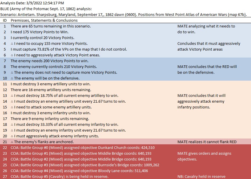
Below is a list of statements, predicates and conclusions generated by MATE during the above analysis with my commentary added on the right:

MATE analysis of Antietam. Click to enlarge.

I recently added a set of algorithms that recognize the composition of battle groups and exploits any possible advantages. For example:
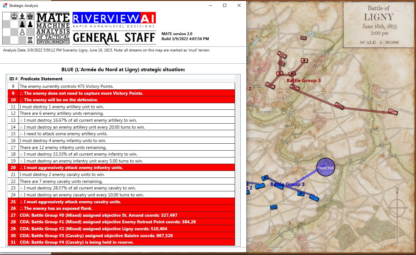
Screen shot showing MATE analysis of BLUE position at Ligny. NB: Battle Group #3 (Pajol’s and Exelmans’ cavalry divisions) are, “snatching the pawn,” at Balatre. Click to enlarge.

At Ligny, above, MATE has recognized that Battle Group #3 and Battle Group #4 are uniquely cavalry (and horse artillery) battle groups and are to be used differently. While Battle Group #4 is held in reserve, Battle Group #3 will snatch Balatre. Though it is valued at only 10 Victory Points, MATE realized that no enemy force could oppose it. That said, I can still hear the voice of my old chess tutor, Mr. Selz,  warning me against ‘pawn snatching’; that is grabbing a minor point that can lead to defeat because the position was not thoroughly analyzed. MATE, however, is correct in this analysis and can safely seize the objective.

While, at Antietam, Battle Group #1 (all the cavalry of the Army of the Potomac commanded by Brigadier General Alfred Pleasonton) is frozen ‘in reserve’. This is not a case where MATE can snatch a pawn. MATE looked at the situation and said, ‘nope’, there are no unattended Victory Points to snatch and there is not an open flank to exploit so, the default setting is ‘in reserve’.

This leads to the interesting conundrum: what exactly was the Union cavalry at Antietam doing? Honestly, I had never really thought of it before. Now, when I look into the question I find, Was McClellan’s Cavalry Deployment at Antietam Doctrinally Sound? This monograph argues that McClellan massing his cavalry in the center for a great coup de grâce exploitation of a breakthrough across the Middle Bridge was acceptable within the framework of Jomini’s theories as taught at West Point before the Civil War. But, then it is countered with this:

In Landscape Turned Red, Stephen Sears has this to say: Shortly before noon, McClellan had ventured to push several batteries across the Middle Bridge, supported by Pleasonton’s cavalry and a force of regulars from George Syke’s Fifth Corps. He was nervous about the move-it was taken against the advice of Porter and Sykes-and he cautioned Pleasonton not to risk the batteries unduly. As an afterthought, he asked, “Can you do any good by a cavalry charge?” Pleasonton wisely ignored the suggestion. – Sears, Stephen, Landscape Turned Red: The Battle of Antietam, New York: Ticknor and Fields, 1983. page 271. (as cited in above)

Would a great massed cavalry attack across Middle Bridge have been suicide? Or brilliant? For the first time in memory I took the 1st edition of McClellan’s Own Story off the shelf and discovered… nothing. McClellan died suddenly of heart failure just as he was writing about Antietam and his memoirs end abruptly with very little insight into his side of the story. But, using cavalry to support horse artillery – rather than the other way around – seemed a bit odd.

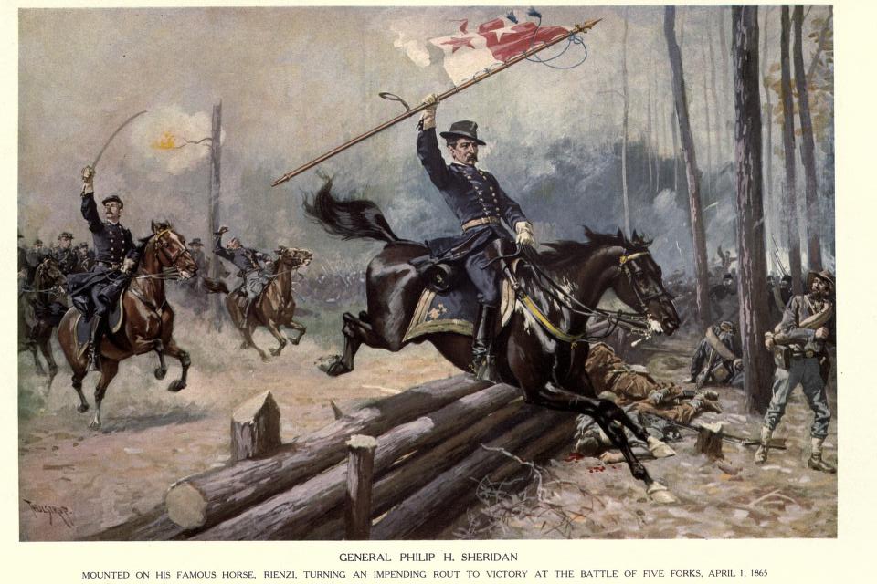
I do not know of any other great cavalry charge in the American Civil War than Sheridan at Five Forks (above). Is this what McClellan envisioned at Antietam? Would it have worked? Could American Civil War regiments have formed square against a massed cavalry charge?

Moving on, let’s drill down to the Course of Action (COA) for Blue Battle Group #3 (Burnside’s IX Corps) at Antietam:
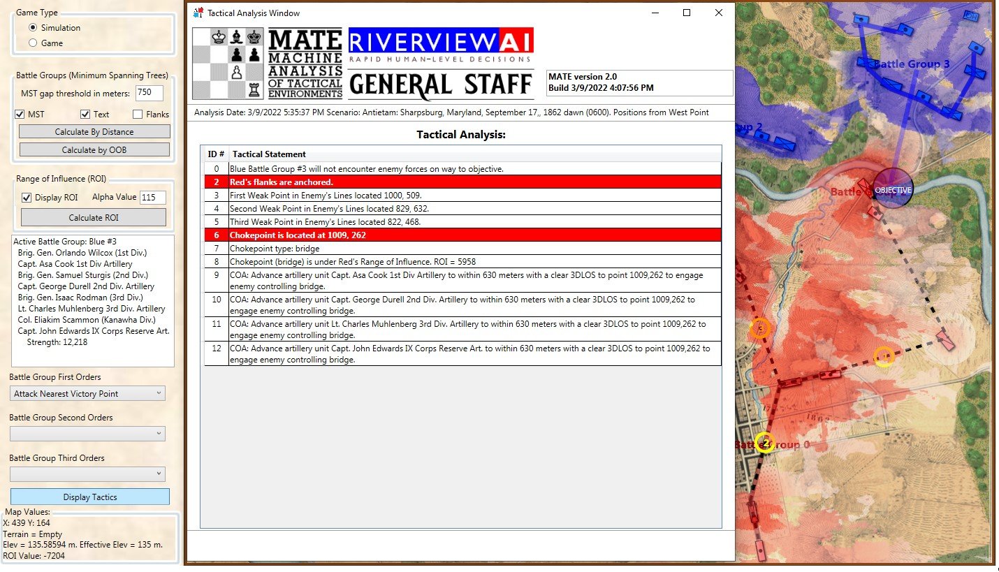
MATE tactical analysis for Blue Battle Group #3 at Antietam (Burnside’s IX Corps). Screen shot. Click to enlarge.

The author walking across Burnside’s Bridge in 1966 (age 12).

The above is MATE’s output that concludes with the COA for Burnside’s IX Corps. Perhaps, the greatest mystery of the battle of Antietam is what took Burnside so long to take this bridge (now forever linked with his name)? It is true that there were numerous, futile and bloody attempts to cross it. Note that MATE, above, recognizes the bridge as a critical Choke Point. When MATE sees a Choke Point that is within the enemy’s control (see statement #8, above, “Chokepoint (bridge) is under Red’s Range of Influence ROI = 5958″ and 5,998 is very high ROI value) it brings up artillery (see statements #9, #10, #11, #12, above). All the artillery in the IX Corps is to be within 630 meters of the objective. Why 630 meters? Because at that distance it is guaranteed a 50% accuracy rate. This rate, by the way, was set in the Army Editor:
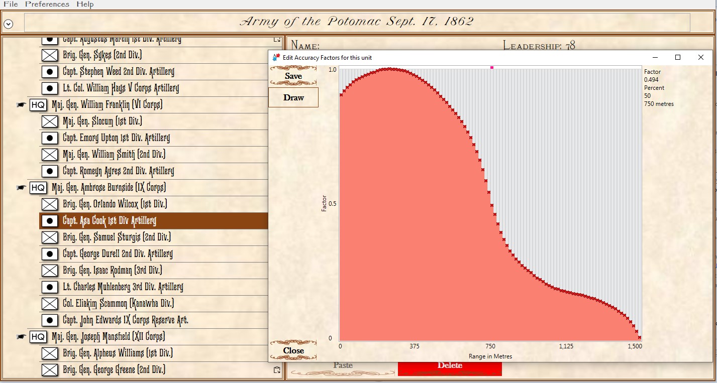
The accuracy curve for the 1st Division, IX Corps artillery as set in the Army Editor. Screen capture. Click to enlarge.

So, MATE says 5)I apologize but I find it easier to describe how the AI works using such phrases as ‘thinks’, ‘says’, and ‘decides’. It’s not worth straining over. Trust me, “My objective is a Choke Point. I’m not sending my units into a meat grinder. I’m sending artillery to a point where they are guaranteed a 50% accuracy per volley and have a clear 3D Line of Sight to the target. This is how I’m going to project as much force as I can at the objective.” War is about force projection. MATE knows this. Is this a better plan than what Burnside actually did? Yeah, it is a lot better with a far greater probability of success. I’ve stood on that plain just east of Burnside’s Bridge and thought that nine batteries of 12 lb. Napoleons aimed at the crest of that hill just beyond the bridge would provide a substantial amount of force projection and covering fire. About half an hour of force projection followed up with an infantry assault would probably take the bridge.

I once described good AI as: Don’t do anything stupid, fast. MATE is doing that. I think MATE is on the way to beat most human opponents because humans do stupid things, fast.

We’ll see. Should be an interesting journey.

References

References
1 MATE: Machine Analysis of Tactical Environments
2 see http://riverviewai.com/download/SidranThesis.pdf
3 a flank that is attached to or protected by terrain, a body of water, or defended fortifications.
4 see pages 45-6 http://riverviewai.com/download/SidranThesis.pdf
5 I apologize but I find it easier to describe how the AI works using such phrases as ‘thinks’, ‘says’, and ‘decides’. It’s not worth straining over. Trust me

Movement & Maps

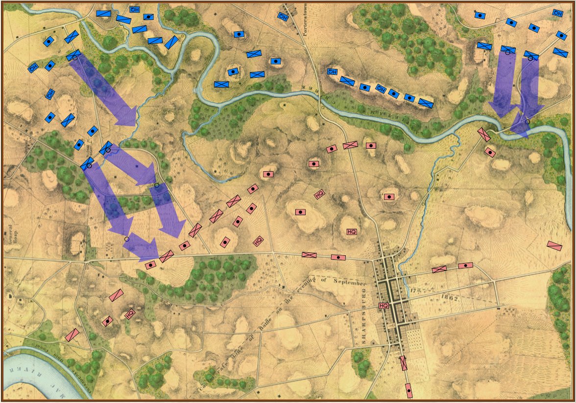
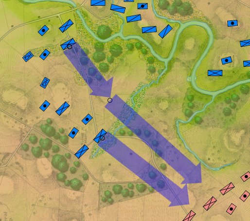
Screen shot showing unit movement arrows for the battle of Antietam scenario. Note how movement is stopped by the small creek in the upper left hand corner of the screen. Click to enlarge.

I‘m in self-quarantine. As many of you know, I had a bone marrow / stem cell transplant in 2014 followed by a year of intense chemo. I’m fine (all things considering) but my immune system took a beating. In 2014 H1N1 put me in the hospital for 3 days so I’m taking COVID-19 seriously as, uh, the plague. In a way, being cooped up in the house (the weather hasn’t been cooperating, either, as I had hoped to replace my daily gym workout with long walks with my dog, George) is a lot like a typical upper Midwestern winter: it’s what I call ‘good programming weather’. There’s not much else to do but hunker down and write code. So, obviously, I’m working on General Staff and I wanted to show you an update (above).

General Staff is being written in C# and Windows Programming Foundation (WPF). There are a number of technical reasons why this was a good idea but I’m not overly familiar with WPF and doing some basic things, like creating these transparent movement arrows, took far longer, and involved a lot more programming, than I thought it would.  My partner on this project, Andy O’Neill, is a WPF rockstar; I’m a novice. I would much rather be working on the ‘under the hood’ stuff (like AI) but for the last week or so I’ve been working on movement arrows while Andy is busy with another project (the kind that pays the rent). Anyway, I’m very pleased about how they turned out. Please feel free to write me with comments.

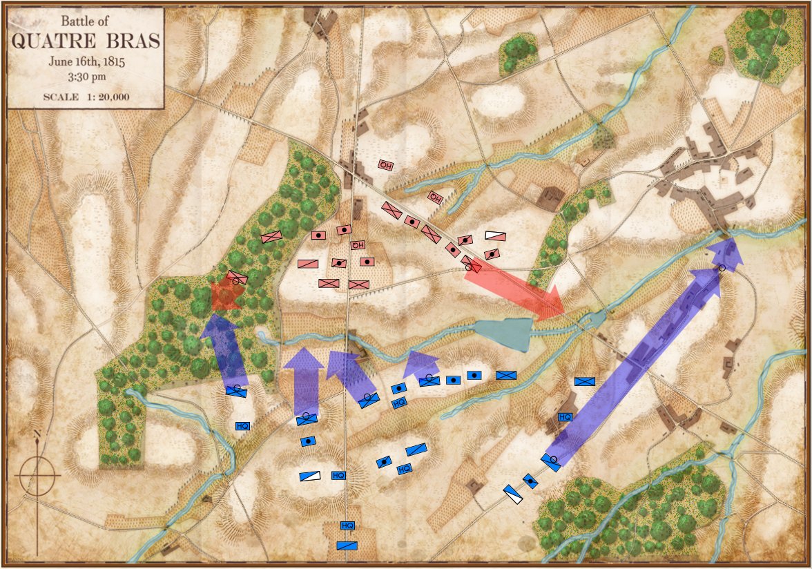
Movement arrows for units at Quatre Bras. Note how blue units are stopped by the stream feeding the large pond. Click to enlarge.

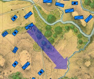
Forward movement of this blue division is stopped by this tiny creek.

But, I also discovered a very interesting problem while testing these movement routines: our maps are too good! If you look at this detail (right) from the Antietam screen capture (above), you’ll see that movement is stopped when it encounters a tiny creek. I’ve walked that area of the Antietam battlefield and that little creek (well, I think it would be more properly called a ‘crick’) wouldn’t stop a division moving forward. However, the movement validation routines stop units from crossing bodies of water (except in column formation while crossing a bridge or a ford).  Ed Kuhrt, who digitized these great maps and copied every small detail was, perhaps, too precise. Definitely better to err on the side of being too precise when it comes to maps, Ed.

We’re seeing the same thing at Quatre Bras (above): the little streams that feed Materne Pond (Etang Materne) are also stopping the French from attacking. I haven’t been to Quatre Bras but I know the French crossed the small streams to attack the Anglo-Allied army’s positions.

Luckily, fixing this is easy. If you have done any work with the General Staff Map Editor you know that erasing terrain features, like water, is quick.

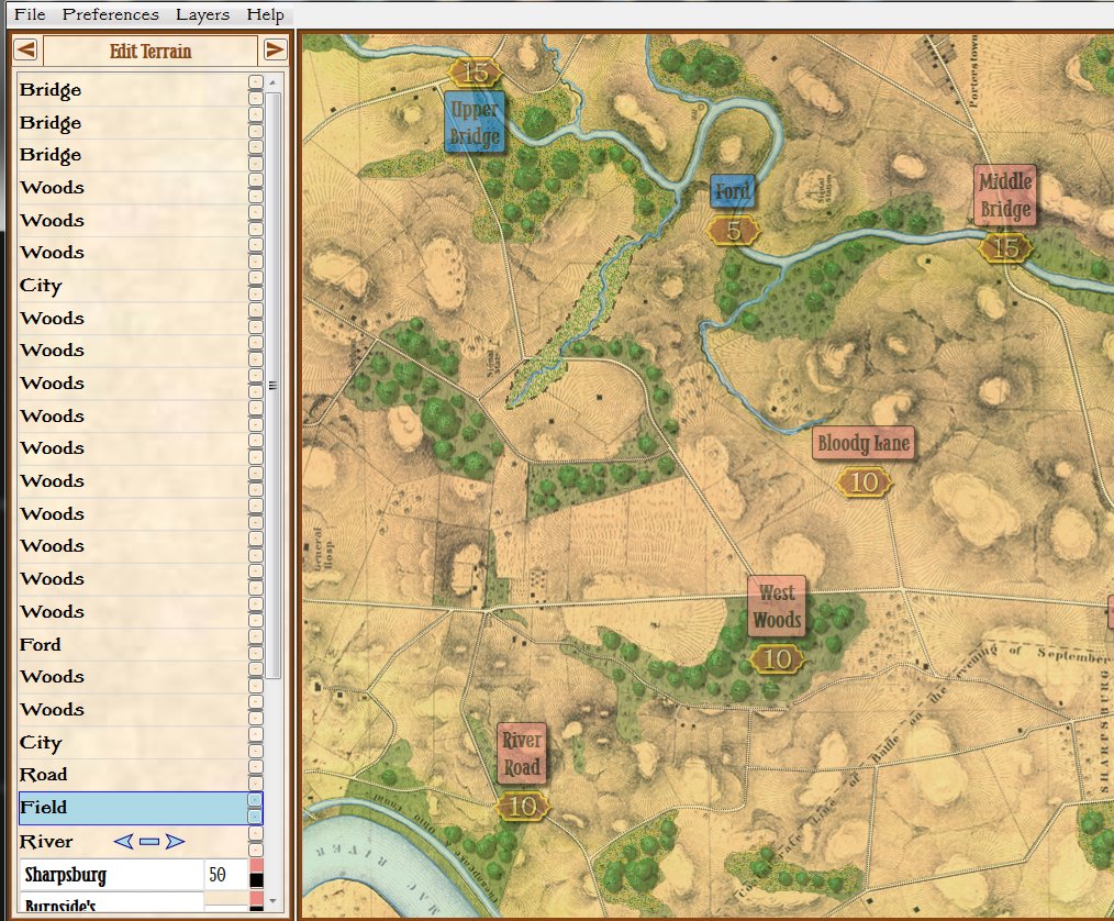
Removing the water in the little stream that feeds Antietam Creek by placing a ‘field’ over the water. Note that the ‘Field’ object is ‘above’ the ‘River’ object on the left Edit Terrain tab. Screen shot. Click to enlarge.

In the above screen shot we’ve opened the Antietam map in the General Staff Map Editor and drawn a ‘Field’ over the ‘crick’ that kept the Union forces from advancing. Note that both the Field and the River are objects and whichever object is higher in the list on the left ‘overwrites’ lower objects. If, for whatever reason, we wanted to restore the water in the creek we could either delete the Field or move it lower down the list than the River object.

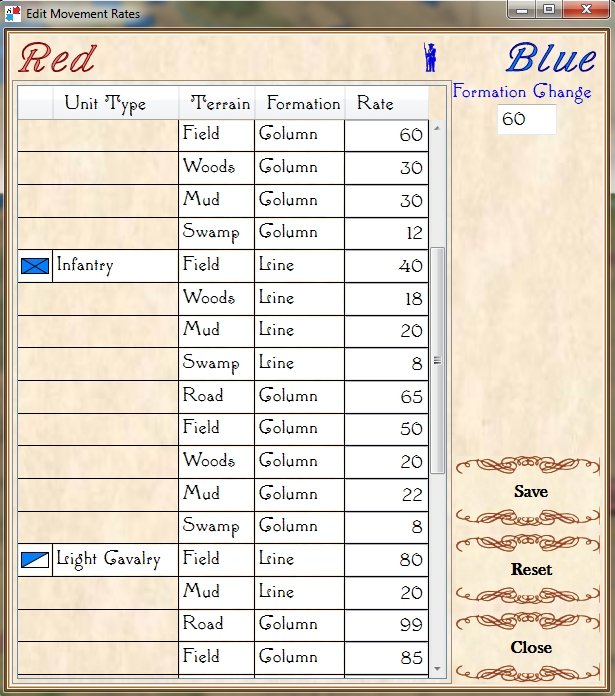
Edit: After originally posting this, some readers (see comments, below) suggested that units crossing a small stream should suffer a movement penalty. This is absolutely correct. Instead of ‘painting’ with ‘field’ terrain, I should have used ‘mud’. This allows for a movement penalty (set in the Scenario Editor).

Adjusting unit type speeds across various terrain types in the General Staff Scenario Editor. Screen capture.

And now that that obstacle to movement has been eliminated the I and XII Union Corps can advance:

Now that the water has been removed from the little stream feeding Antietam Creek the Union forces can advance again. Screen shot.

As always, I would love to hear any comments or feedback that you may have.

Thank You Wargaming Community!

Last week I posted an appeal to the wargaming community and backers of The General Staff Wargaming System that I needed more maps and Orders of Battle (OOBs). The General Staff Wargaming System is designed to handle any conflict in the Black Powder era and the machine learning AI needs as much input as possible.

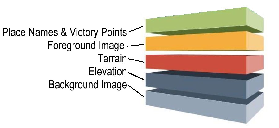
The five layers that make up a General Staff map.

The General Staff Army Editor makes it pretty easy to create four of the five layers of a map file (see above). The problem is the beautiful background image that the user sees on screen (the computer AI couldn’t care less about the visual map). I’ve been able to locate a lot of great maps; especially from the American Civil War and the US Library of Congress but we still need more.

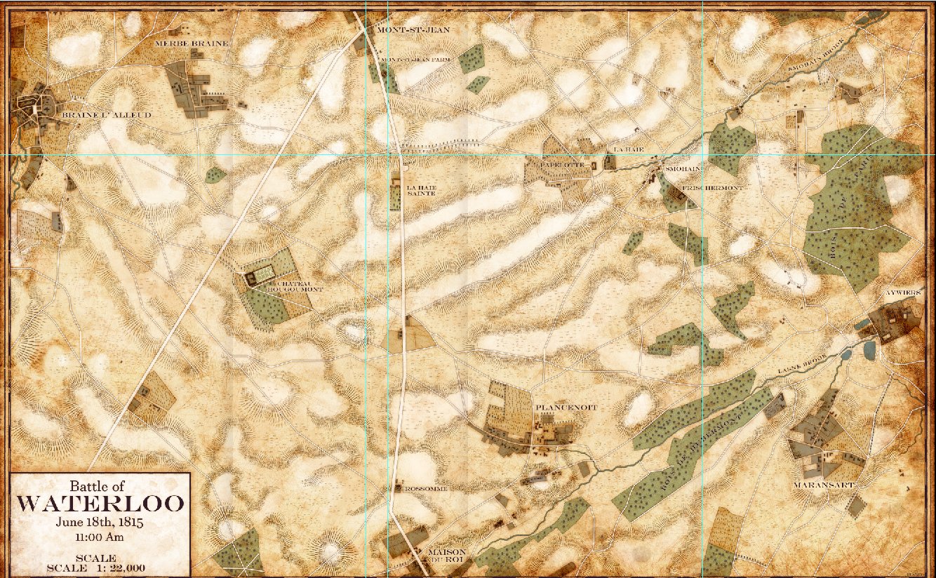
Waterloo from Glenn Drover (Forbidden Games) and Jared Blando. Click to enlarge.

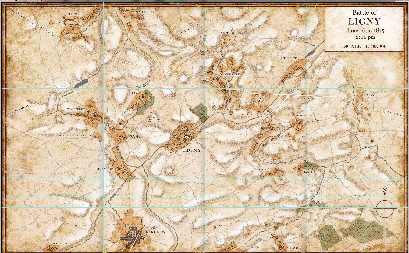
A couple of days ago I received an email from the famous game designer, Glenn Drover (Forbidden Games), who offered us the use of three maps that he had researched and were drawn by artist Jared Blando. Here’s a link to Forbidden Games’ site. Please check out their fantastic board games!

Ligny from Glenn Drover (Forbidden Games) and Jared Blando. Click to enlarge.

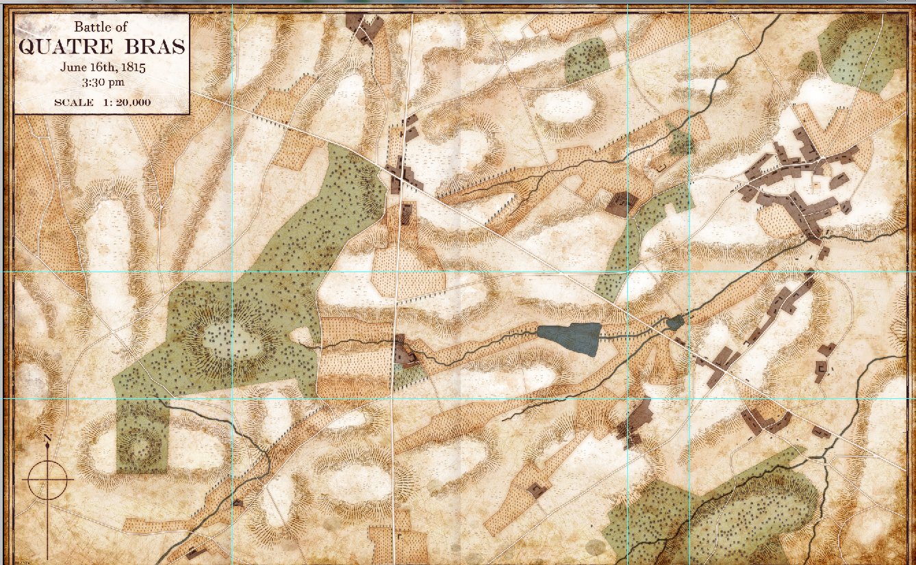
The three battlefield maps were Waterloo, Ligny and Quatre Bras.

Quatre Bras from Glenn Drover (Forbidden Games) and Jared Blando. Click to enlarge.

What is especially amazing is how well these three maps fit the style that I’ve wanted to create for General Staff.

In addition to these three great maps, which we will definitely be using for the battles of Waterloo, Ligny and Quatre Bras, I’ve received emails from a number of other wargamers who have offered to research OOBs; especially some in another language.

I am completely blown away (I know it’s a cliche, but I don’t have any other words) by the kindness and generosity shown me by the wargaming community. Thank you very much!

AI Routines Added But We Need More Testing Data (Maps & Armies)

The AI routines for calculating battle lines and range of influence have been ported over from the original C++ code to C#:

Antietam displaying Range of Influence and Battle Lines. Click to enlarge.

I’ve written a number of blog posts about these AI routines which you may find interesting:

Battle Lines, Commanders & Computers

What’s Wrong With This Picture?

Wargame AI Continued: Range of Influence

That’s the good news. The bad news is that I’m also installing the Machine Learning AI that was the basis of my doctoral research and it needs more battles to learn from. A lot more. Currently there are 15 armies (click here) and 5 maps (click here). Ideally I would like about 50 armies and 30 maps used to create 30+ battle scenarios.

Are you a cartographer or a researcher?  If you are, and you’re interested, I could use your help if you would like to volunteer. All the maps and armies were created using the tools that you, as a backer, have already been provided: The General Staff Army Editor and The General Staff Map Editor. A little bit of PhotoShop or another paint program was used to clean up the old maps and a free program, Inkscape, was used to create the paths for roads and rivers. The most difficult task is the research. Finding Order of Battle Tables (OOBs) are pretty easy but General Staff requires knowing the actual troop strength of every unit. Sometimes, that is very hard to find. For the maps, adding elevation is usually the most difficult bit, but there are a number of built-in tools to make this easier.

If you’re interested in helping add to the data files please contact me directly: [email protected].

Maps, Commanders & Computers

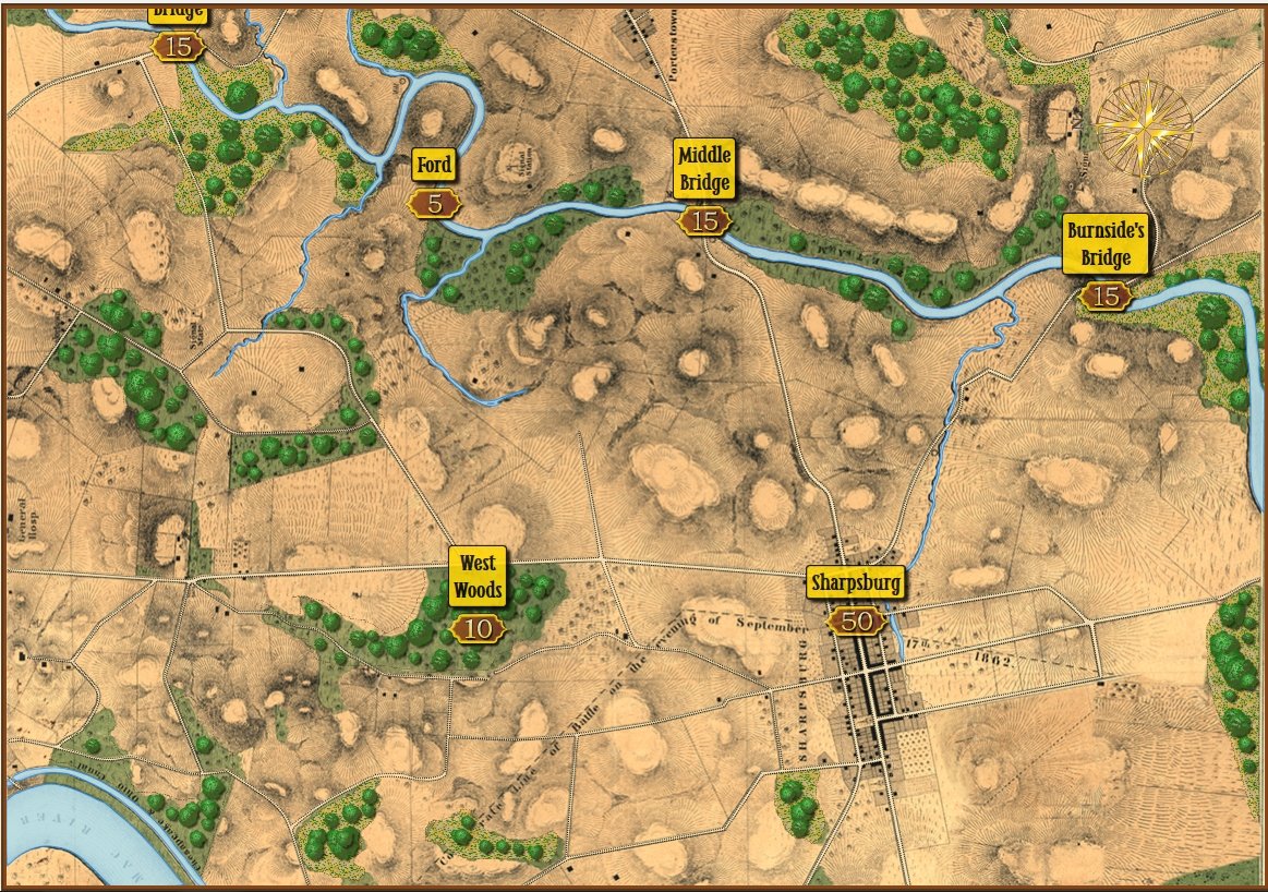
How a map of the battle of Antietam looks to us humans. Screen shot from the General Staff Map Editor. Click to enlarge.

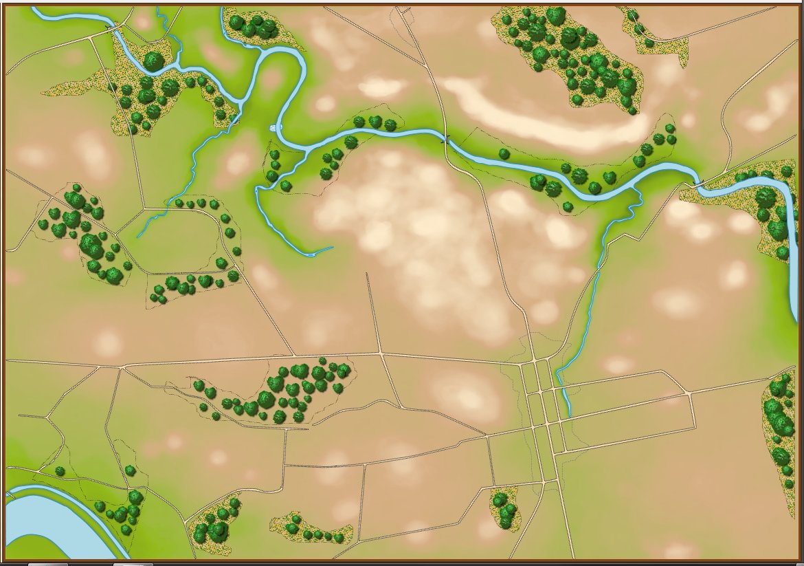
How the computer sees the same map (terrain and elevation). This is actually a screen shot from the Map Editor with the ‘terrain’ and ‘elevation’ layers turned on. Click to enlarge.

Computer vision is the term that we use to describe the process by which a computer ‘sees'1)When describing various AI processes I often use words like ‘see,’ ‘understand,’ and ‘know’ but this should not be taken literally. The last thing I want to do is to get in to a philosophic discussion on computers being sentient. the world in which it operates. Many companies are spending vast sums of money developing driverless or self-driving cars. However, these AI controlled cars have had a number of accidents including four that have resulted in human fatalities.2)https://en.wikipedia.org/wiki/List_of_self-driving_car_fatalities The problem with these systems is not in the AI – anybody who has played a game with simulated traffic (LA Noir, Grand Theft Auto, etc.) knows that. Instead, the problem is with the ‘computer vision’; the system that describes the ‘world view’ in which the AI operates. In one fatality, for example, the computer vision failed to distinguish a white semi tractor trailer from the sky.3)https://www.theguardian.com/technology/2016/jun/30/tesla-autopilot-death-self-driving-car-elon-musk Consequently, the AI did not ‘know’ there was a semi directly in front of it.

In my doctoral research I created a system by which a program could ‘read’ and ‘understand’ a battlefield map4)TIGER: An Unsupervised Machine Learning Tactical Inference Generator http://www.riverviewai.com/download/SidranThesis.html. This is the system that we use in General Staff.

The two images, above, show the difference in how a human commander and a computer ‘see’ the same battlefield. In the top image the woods, the hills and the roads are all obvious to us humans.

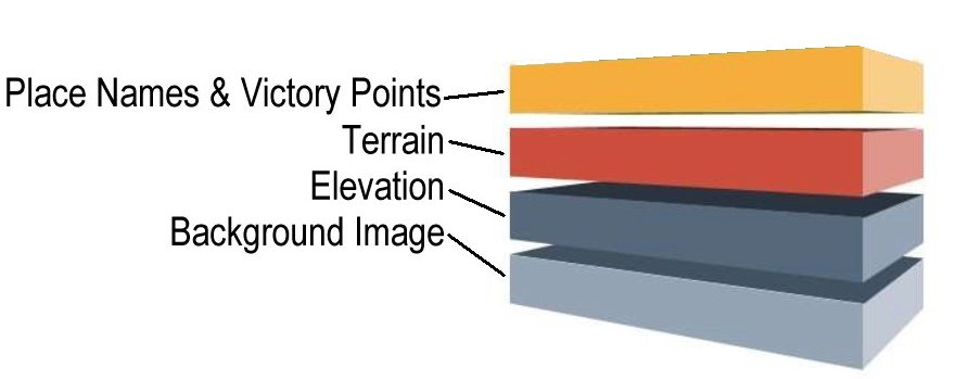
The bottom, or ‘computer vision’ image, is a bit of a cheat because this is how the computer information is visually displayed to the human designer in the General Staff Map Editor. The bottom image is created from four map layers (any of which can be displayed or turned off):

The four layers that make up a General Staff map.

The background image layer in a General Staff map is the beautiful artwork shown in the top image. The place names and Victory Points layer are also displayed in the top image. The terrain and elevation layers are described below:

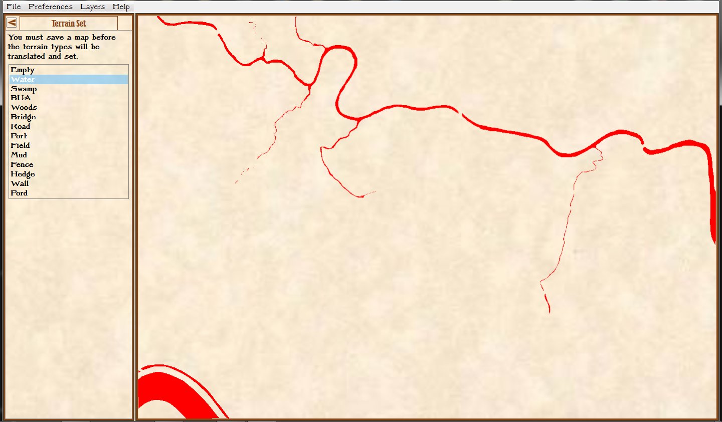
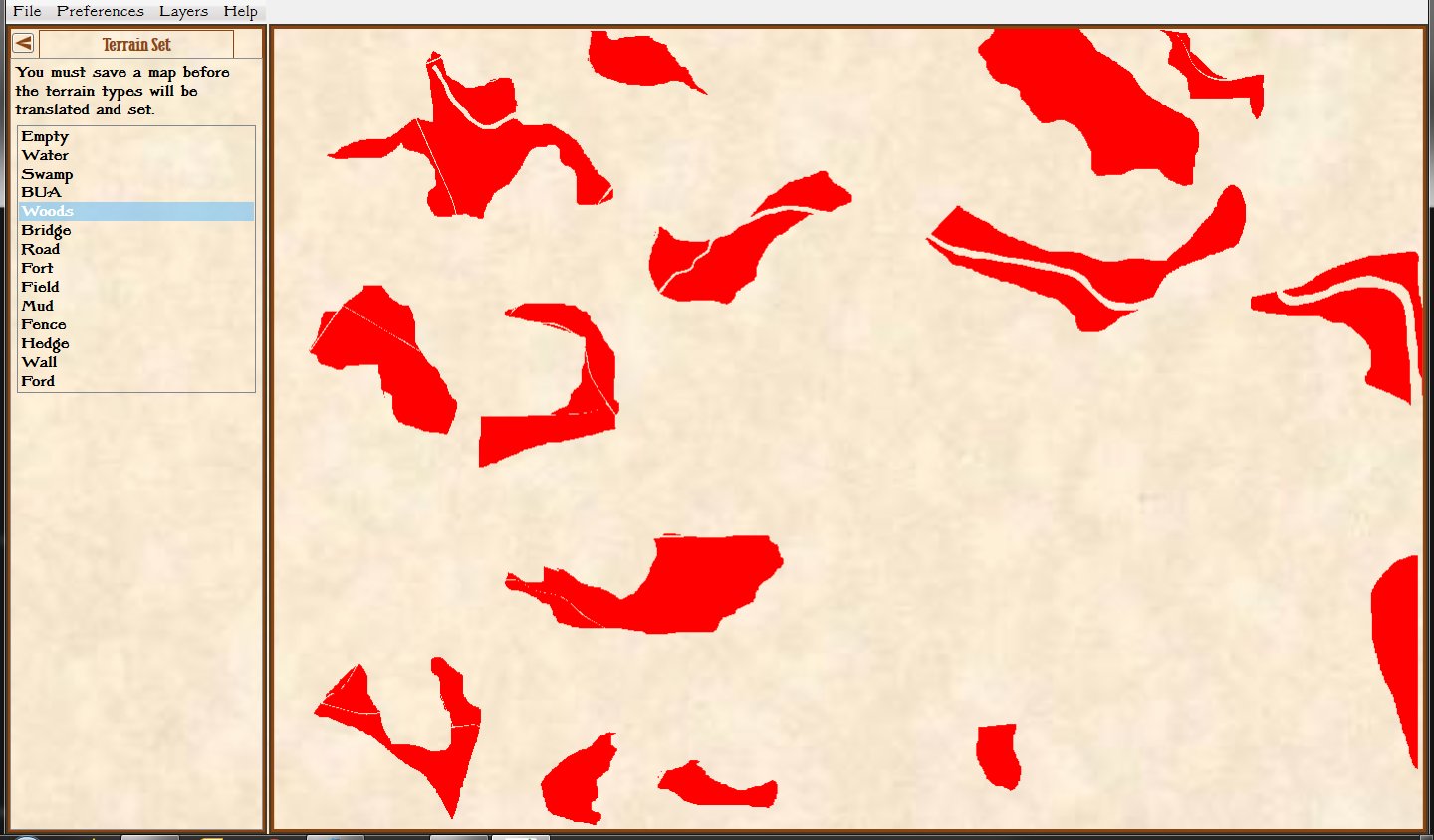
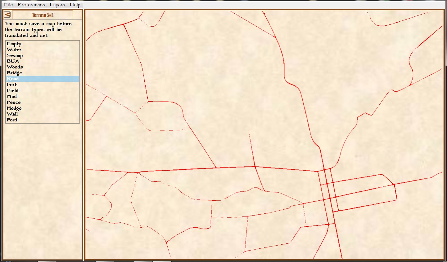
The next three images are actual visual representations of the contents of memory where these terrain values are stored (this is built in to the General Staff Map Editor as a debugging tool):

Screen shot from the Map Editor showing just terrain labeled as ‘water’. Click to enlarge

Screen shot from the General Staff Map Editor showing the terrain labeled as ‘woods’. Click to enlarge.

Screen shot from the General Staff Map Editor showing the terrain labeled ‘road’. Click to enlarge.

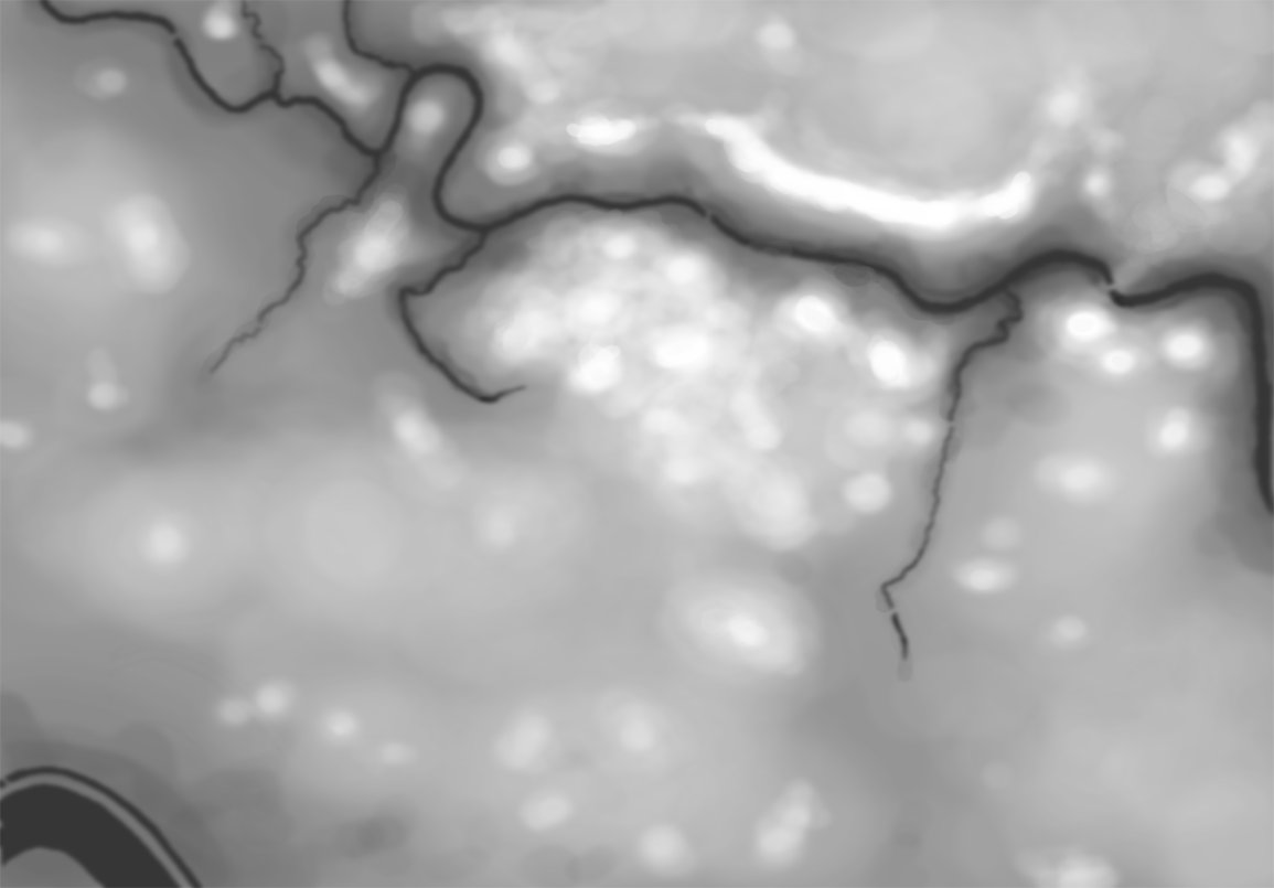
A heightmap for Antietam. This is a visual representation of elevation in meters (darker = lower, lighter = higher). Click to enlarge.

To computers, an image is a two-dimensional array; like a giant tic-tac-toe or chess board. Every square (or cell) in that board contains a value called the RGB (Red, Green, Blue5)Except in France where it’s RVB for Rouge, Vert, Bleu  ) value. Colors are described by their RGB value (white, for example, is 255,255,255).  If you find this interesting, here is a link to an interactive RGB chart. General Staff uses a similar system except instead of the RGB system each cell contains a value that represents various terrain types (road, forest, swamp, etc.) and another, identical, two-dimensional array, contains values that represent the elevation in meters. To make matters just a little bit more confusing, computer arrays are actually not two-dimensional (or three-dimensional or n-dimensional) but rather a contiguous block of memory addresses. So, the terrain and elevation arrays in General Staff which appear to be two-dimensional arrays of 1155 x 805 cells are actually just 929,775 bytes long hunks of contiguous memory. To put things in perspective, just those two arrays consume more RAM than was available for everything in the original computer systems (Apple //e, Apple IIGS, Atari ST, MS DOS, Macintosh and Amiga) that I originally wrote UMS for.

So, not surprisingly, a computer stores its map of the world in which it operates as a series of numbers 6)Yes, at the lowest level the numbers are just 1s and 0s but we’ll cover that before the midterm exams. that represent terrain and elevation. But, how does a human commander read a map? I posed this question to Ben Davis, a neuroscientist and wargamer, and he suggested looking at a couple of studies. In one article7)https://www.citylab.com/design/2014/11/how-to-make-a-better-map-according-to-science/382898/, Amy Lobben, head of the Department of Geography at the University of Oregon, said, “…some people process spatial information egocentrically, meaning they understand their environment as it relates to them from a given perspective. Others navigate more allocentrically, meaning they look at how other objects in the environment relate to each other, regardless of their perspective. These preferences are linked to different regions of the brain.” Another8)https://www.researchgate.net/publication/251187268_USING_fMRI_IN_CARTOGRAPHIC_RESEARCH reports the results of fMRI scans while, “subjects perform[ed] navigational map tasks on a computer and again while they were being scanned in a magnetic resonance imaging machine.” to identify specific, “involvement or non-involvement of the brain area.. doing the task.”

So, how computers and human commanders read and process maps is quite different. But, at the end of the day, computers are just manipulating numbers following a series of algorithms. I have written extensively about the algorithms that I have developed including:

  • “Algorithms for Generating Attribute Values for the Classification of Tactical Situations.”
  • “Implementing the Five Canonical Offensive Maneuvers in a CGF Environment.”
  • “Good Decisions Under Fire: Human-Level Strategic and Tactical Artificial Intelligence in Real-World Three-Dimensional Environments.”
  • “Current Methods to Create Human-Level Artificial Intelligence in Computer Simulations and Wargames”
  • Human Level Artificial Intelligence for Computer Simulations and Wargames.
  • An Analysis of Dimdal’s (ex-Jonsson’s) ‘An Optimal Pathfinder for Vehicles in Real-World Terrain Maps’

These papers, and others, can be freely downloaded from my web site here.

As always, please feel free to contact me directly if you have any questions or comments.

References

References
1 When describing various AI processes I often use words like ‘see,’ ‘understand,’ and ‘know’ but this should not be taken literally. The last thing I want to do is to get in to a philosophic discussion on computers being sentient.
2 https://en.wikipedia.org/wiki/List_of_self-driving_car_fatalities
3 https://www.theguardian.com/technology/2016/jun/30/tesla-autopilot-death-self-driving-car-elon-musk
4 TIGER: An Unsupervised Machine Learning Tactical Inference Generator http://www.riverviewai.com/download/SidranThesis.html
5 Except in France where it’s RVB for Rouge, Vert, Bleu
6 Yes, at the lowest level the numbers are just 1s and 0s but we’ll cover that before the midterm exams.
7 https://www.citylab.com/design/2014/11/how-to-make-a-better-map-according-to-science/382898/
8 https://www.researchgate.net/publication/251187268_USING_fMRI_IN_CARTOGRAPHIC_RESEARCH