Category Archives: Artificial Intelligence

Why Machines May Kill Us In Our Sleep

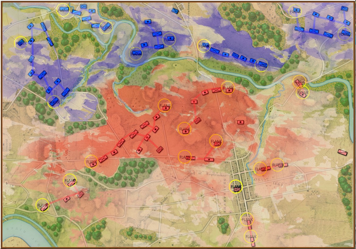
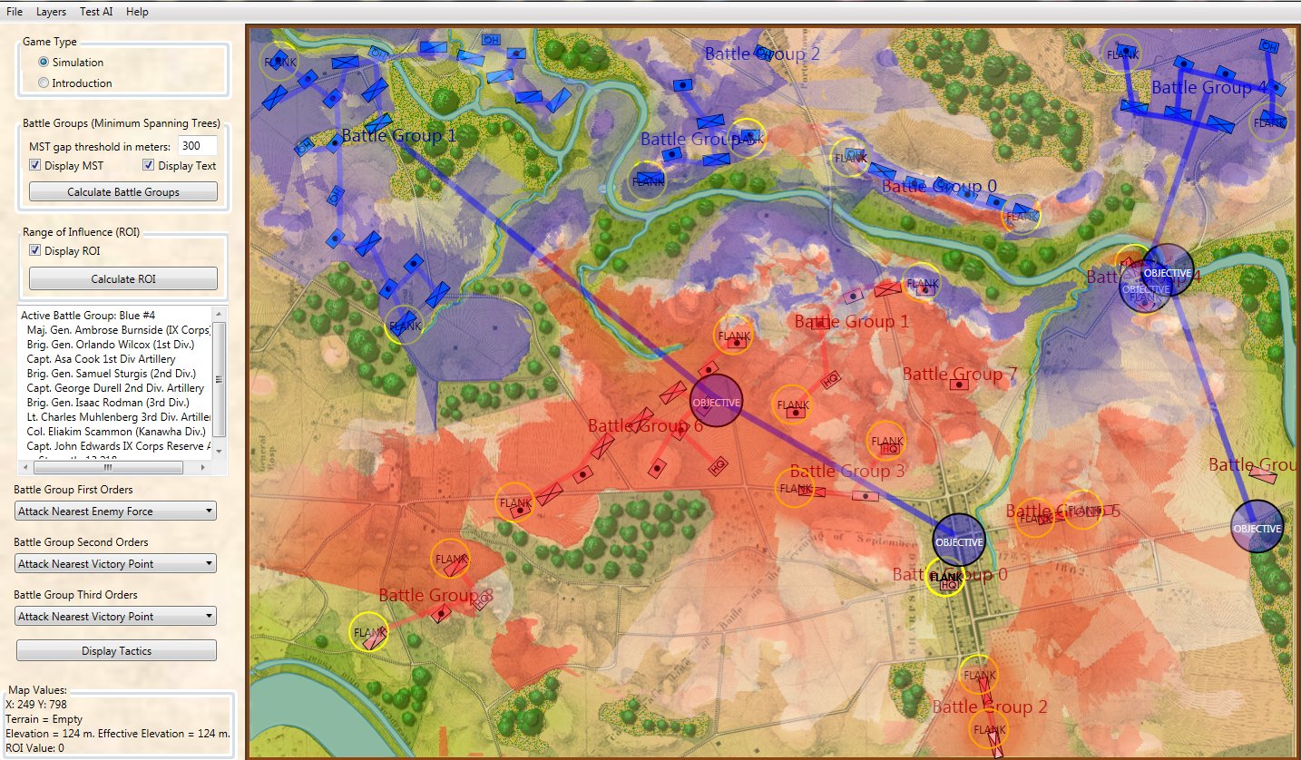
An amazing screen capture of the AI’s solution to a problem. It has found a 1 pixel gap between the data and the edge of the screen and is exploiting it to successfully find an ‘open flank’ of Red. Click to enlarge.

Professor Alberto M. Segre was my thesis advisor and one day he said to me, “You know when your AI is really working because it will surprise you.” Today I got to have one of those weird surprises.

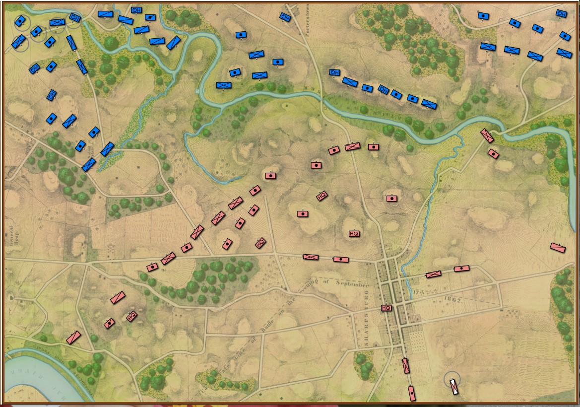
The screen shot (above) is a visual representation of what the AI is up to. You won’t get to see this in the actual game. The program that’s running is called the AI Editor which is a bit of a misnomer because you don’t actually edit the AI in it; you mostly just get to observe what it’s doing. There’s a lot of stuff going on in the above image. There are multiple layers visually displaying different types of data (check out the blog – Layers: Why a Military Simulation is Like a Parfaitfor more information about these). But, what interests us are the AI layers: Battle Groups, Objectives, and that thin yellow line that snakes from a group of blue units, crossing Antietam Creek at the Middle Bridge and then, amazingly, exploiting a data anomaly to reach its goal: a point far behind enemy lines.

Some background on the situation:

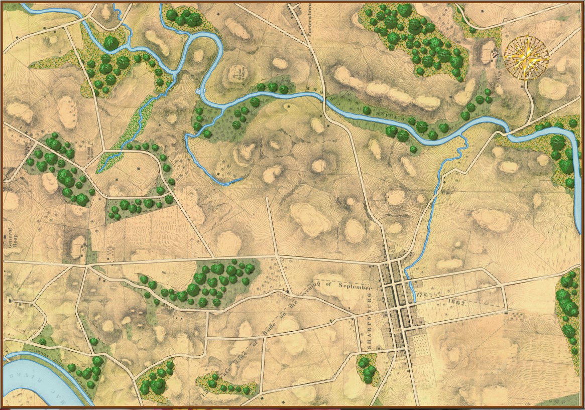
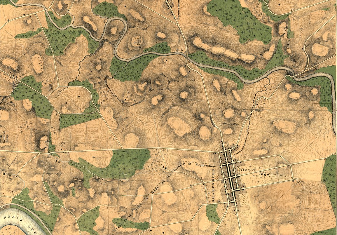
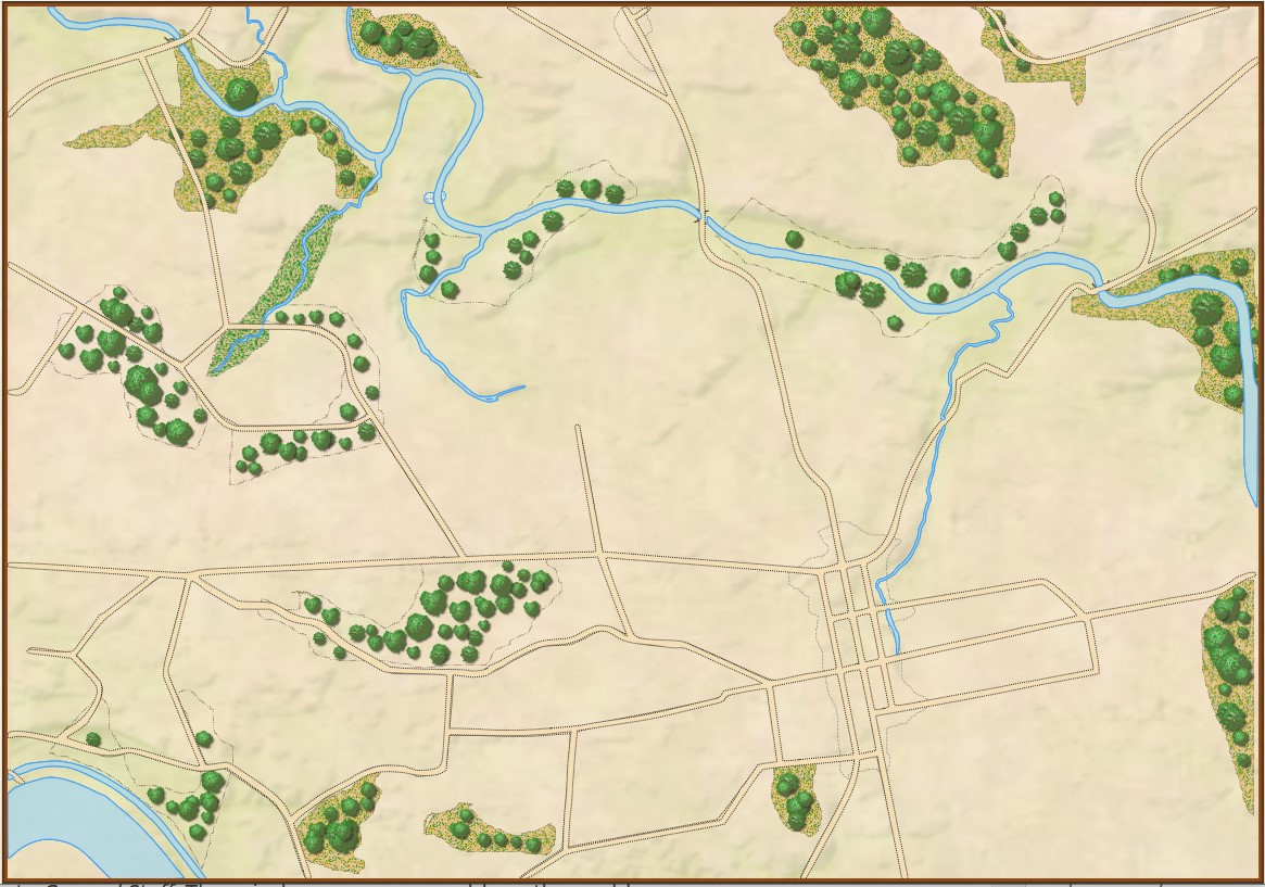
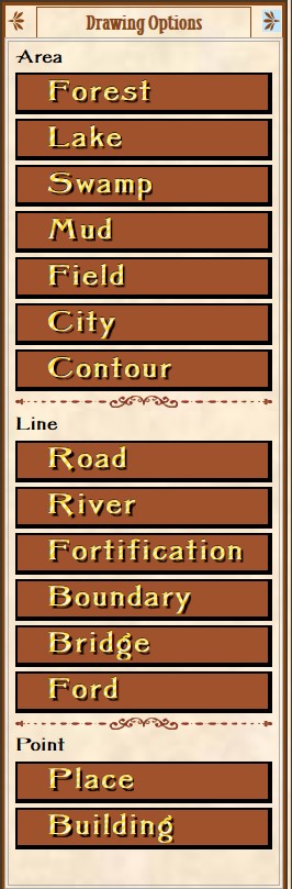
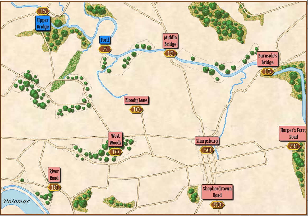
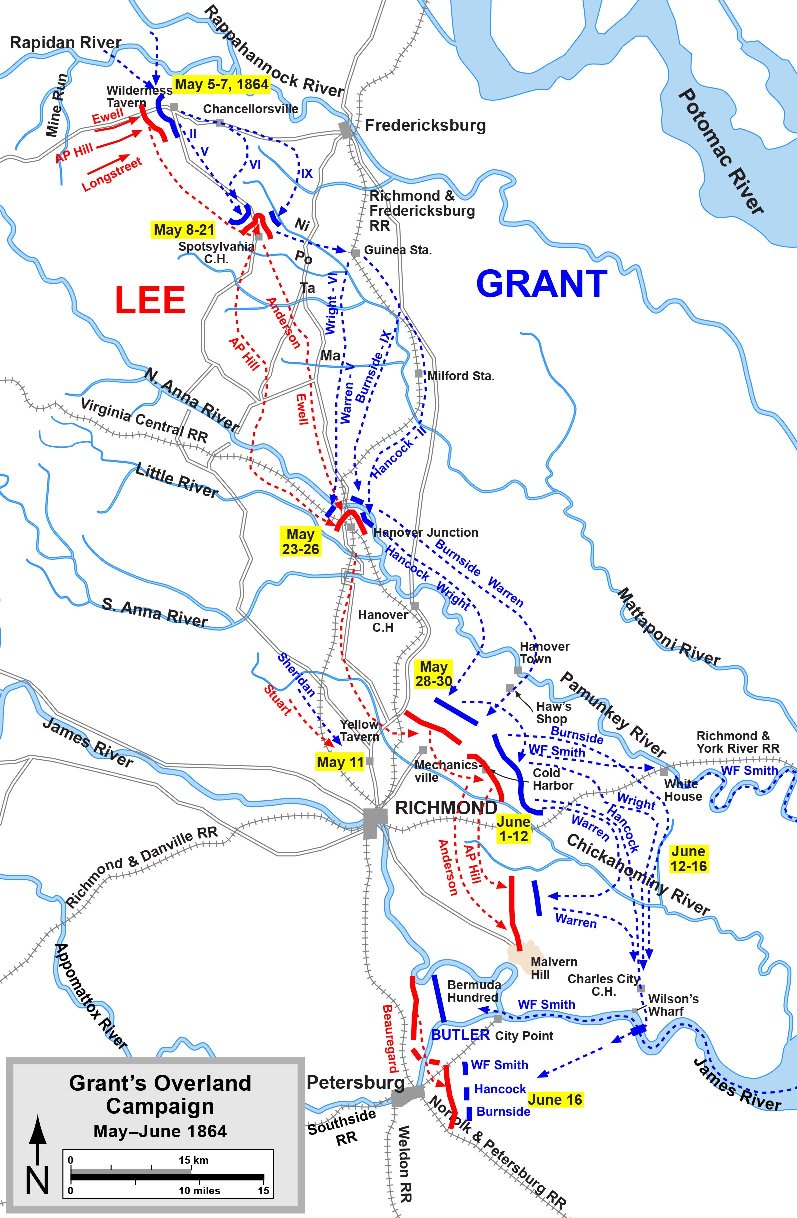
The map of the Antietam Battlefield (screen shot) with terrain and elevation layers displayed. Click to enlarge.

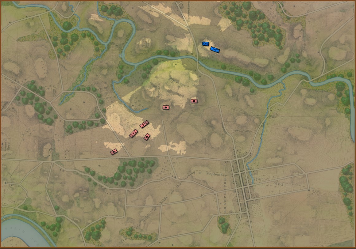
Underlying all the clutter from the first screen capture, top, is the battle of Antietam (above). The map has been rotated 90 degrees to the left so north is now pointing to the left; east is at the top of the screen.

After adding Blue (Union) and Red (Confederate) units to the map in their historical positions at 0600 September 17, 1862 the AI performed a tactical analysis from the perspective of Blue.

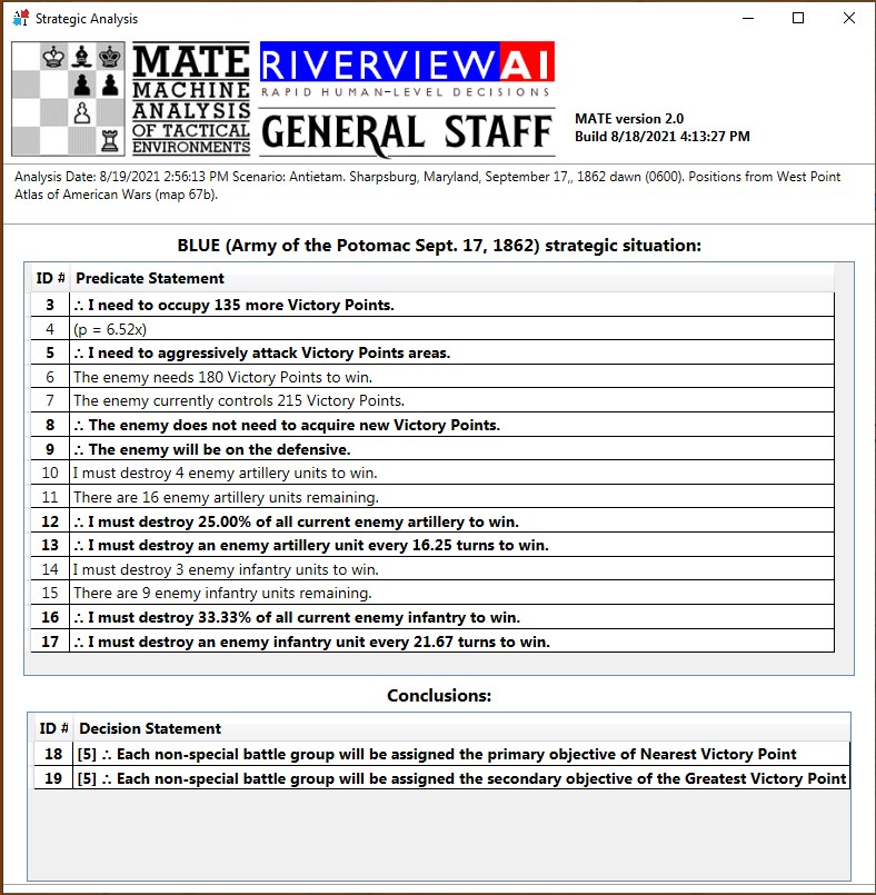
The AI ‘strategic’ analysis for Antietam playing Blue (Union).

The above are a list of Predicate Statements all of which the AI knows to be true. Statements preceded by the logical sign ∴ (therefore) are conclusions, or inferences, derived from the predicate statement referenced in the brackets. It is this analysis that determines if the AI will be on the offensive or defensive and what its objectives will be.

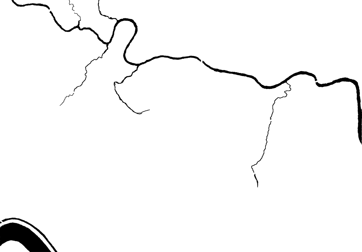
Next, the AI performs Range of Influence (ROI) calculations for the entire observable battlefield. I plan on doing a video about this later, but for now the darker the red (in the topmost screen capture) the more – and more powerful – weapons the Red army can bear on that point.  The AI next divides all the units on the map into a forest of minimum spanning trees called Battle Groups. I want to do a video about this, too. However, if you can’t wait, these subjects are covered in my paper, Implementing the Five Canonical Offensive Maneuvers in a CGF Environment (free download).

Again, referring to the top screenshot you can see the AI’s calculations to this point:

  • It has determined it (Blue) will be on the offensive.
  • It has calculated enemy ROI.
  • It has assigned objectives to the first Battle Group.

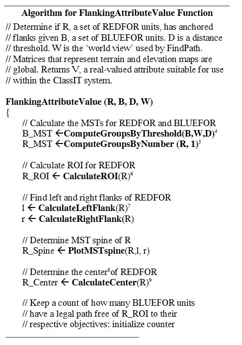
Flanking Algorithm published in, “Algorithms for Generating Attribute Values for the Classification of Tactical Situations”. Click to enlarge.

Now the AI needs to determine if the enemy has an ‘open or unanchored flank’. In Algorithms for Generating Attribute Values for the Classification of Tactical Situations I published the Algorithm for Flanking Attribute Value Function (right). It basically comes down to this: can the AI trace an unbroken path from the center of the Blue Battle Group to a specific point (called the Retreat Point) far behind enemy lines without crossing into ‘No Go Areas’ (water, swamp) or entering any area controlled by Red’s ROI (literally the red areas in the topmost screen shot).

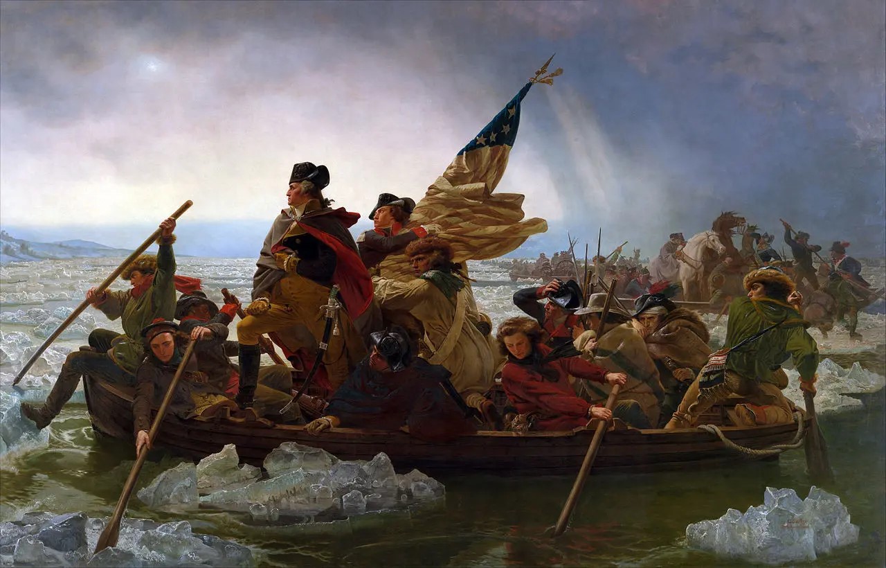
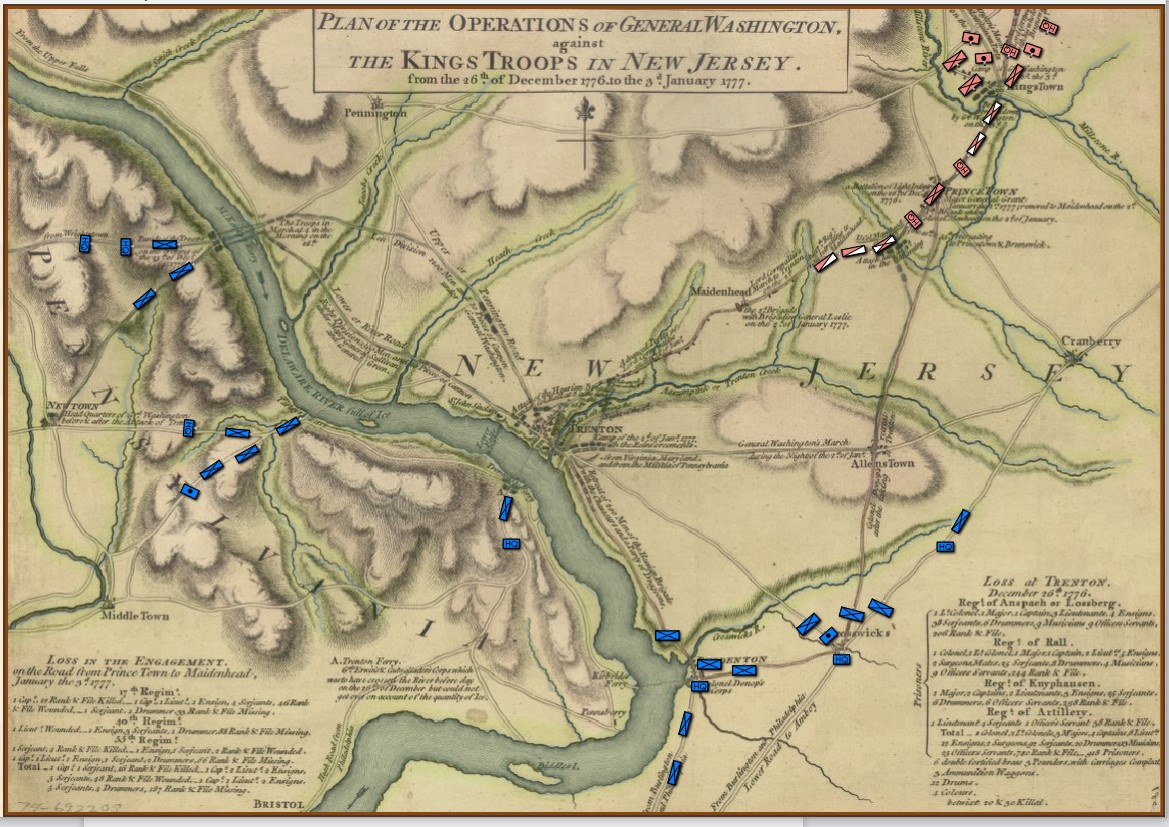
The reason that I was using Antietam as a test case for anchored / unanchored flanks is because years ago I had analyzed the battle for my doctoral thesis and knew it to be a classic example of anchored flanks; Lee’s left flank rests on the Potomac and his right flank is anchored on the Antietam. Granted, the Confederate flanks were held by Stuart’s cavalry with a little horse artillery support but they were still, by definition, anchored flanks.

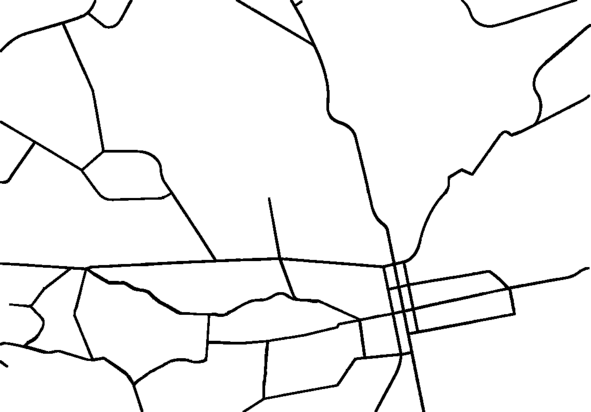
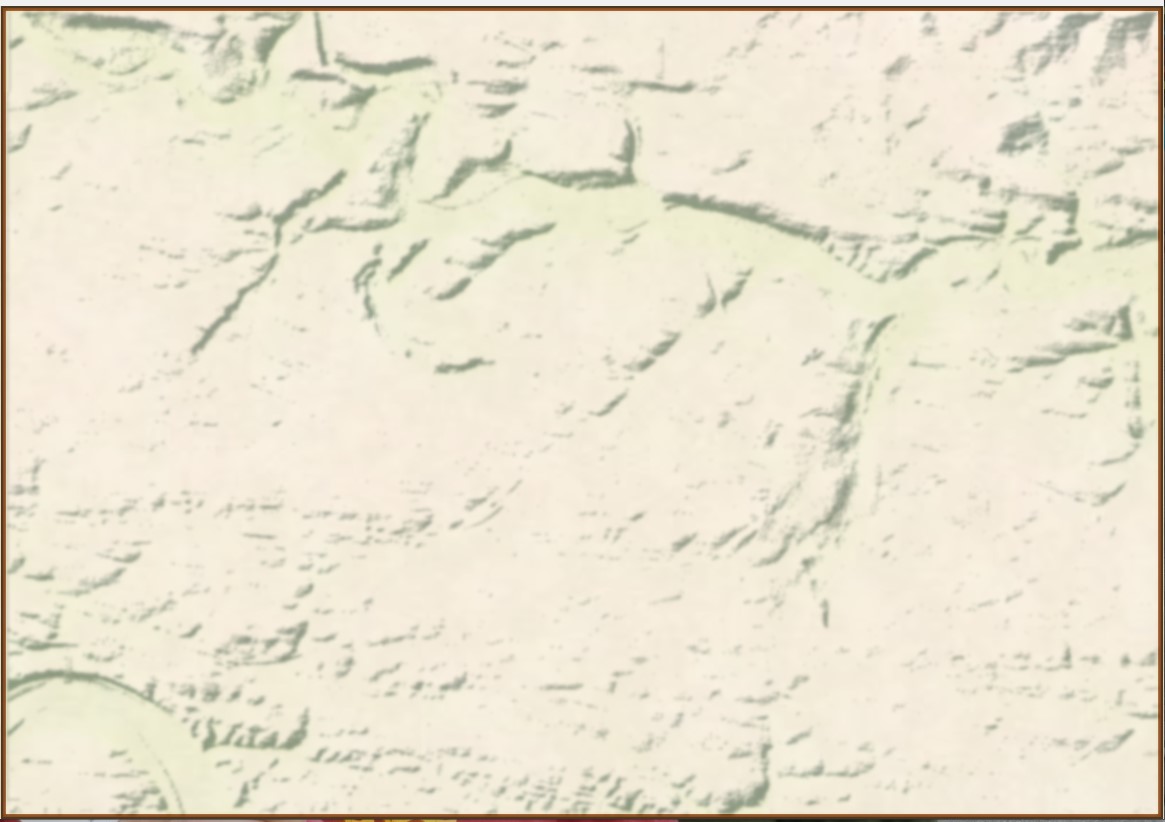
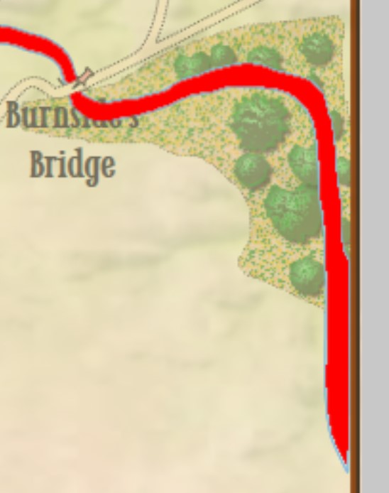
Due to an error in the data that made up the Antietam terrain map a 1 pixel (about 3.8 meter wide) strip of ‘no terrain’ was inserted at the far right hand edge of the map (see blow up of screen capture, right; it’s the thin line between the water, represented in red, and the brown edge of the map). This meant there was a ‘land bridge’ across Antietam Creek where none existed in real life. A digital parting of the Red Sea, if you will. But, by the rules of the game the AI perfectly performed its function. There was no error in the AI – again, the AI performed better than I had dared hope – the error was with the data set.

And that’s how fifty years from now I can see a cyber-detective standing over the chalk marks around a body saying, “Yeah, the machine performed perfectly, brilliantly, in fact. But, the error in the data set killed him.”

It’s already happened in real life. For cars with autopilot the data set of the world in which it operates is crucial. However, “against a bright spring sky, the car’s sensors system failed to distinguish a large white 18-wheel truck and trailer crossing the highway, Tesla said. The car attempted to drive full speed under the trailer, “with the bottom of the trailer impacting the windshield of the Model S”, Tesla said.” The driver died. The AI functioned perfectly. But, the error in the data set killed him.

So, I fixed the error in the data set (probably caused by not using the right values in InkScape when I converted the Antietam Water.bmp into paths) and imported it back into the Antietam map using the General Staff Map Editor, saved it out, and ran the AI Editor again and saw this:

The AI did not display a yellow path from the center of the Blue Battle Group to the Red Retreat Point because none existed. Instead, it just wrote the first Predicate Statement in the Tactical Analysis stack: “Red’s flanks are anchored”.

Again, the machine was performing perfectly. And its results were no longer surprising.

Addendum

I recently got to experience this again (though this time it was caused by a different data bug) when I was reviewing the AI’s decisions at the battle of Manassas:

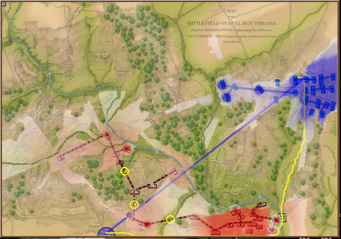
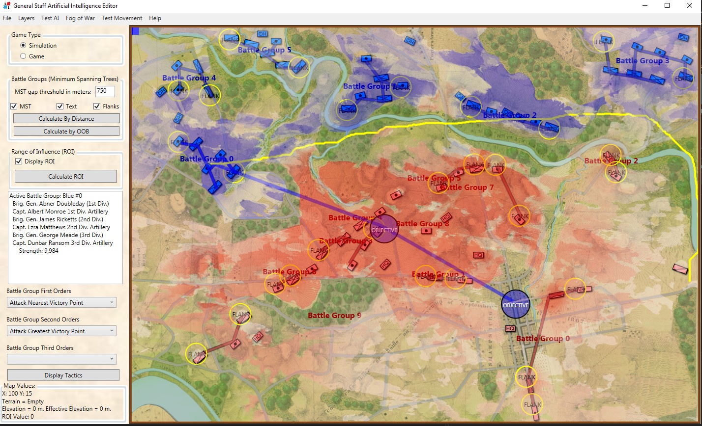
Because the Range of Influence was not calculating the very bottom row the AI found another, perfectly legal, way to reach its goal. Screen shot from the General Staff AI Editor. Click to enlarge.

In this instance, the error in the database was caused by the Range of Influence (basically a map of what red and blue can see and hit) not calculating the very last row. Consequently, the AI was able to legally trace a path from the blue forces in the northeast to their goal at the bottom of the map.

After this bug was corrected the AI performed as expected:

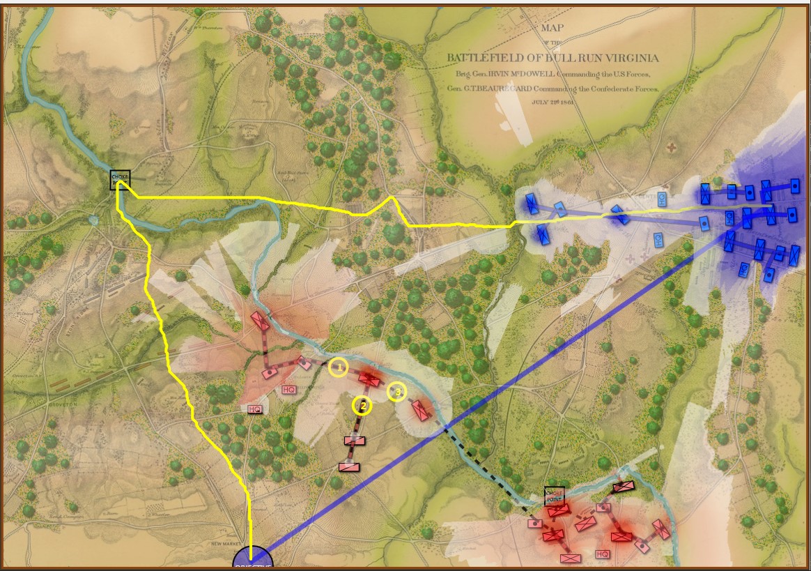
The AI correctly sees going around red’s left flank as the solution to the problem. Screen shot from General Staff AI Engine. Click to enlarge

In the above screen shot the AI has demonstrated the correct solution to the tactical problem facing blue at Manassas on July 20, 1861 (the day before the actual battle). Red’s left flank is unanchored. It’s wide open. Note how the AI identifies the one choke point (Sudley Springs Ford) in the plan.

So, the AI surprised me again. I think it’s looking pretty good. When you play against it, watch your flanks.

I Was Wrong About George Washington

Washington Crossing the Delaware by Emmanuel Luetze. 1851. The Metropolitan Museum of Art. Click to enlarge.

I must confess that I was never much a fan of George Washington’s generalship. Having not studied American Revolution military history I thought that from 1776-1781 the British chased Washington and his sad excuse for an army up and down the eastern seaboard of what was to become the United States until the French Comte de Grasse defeated the British naval forces at the Battle of the Chesapeake and the Comte de Rochambeau at the head of a French army surrounded, besieged and eventually captured, Cornwallis at Yorktown.

To make matters worse, years ago I stumbled upon George Washington’s Expense Account which is, frankly, brutal. Washington turned down the magnanimous salary of $500 a month for being Commander in Chief of the Continental Army famously saying,

“As to pay, Sir, I beg leave to Assure the Congress that as no pecuniary consideration could have temped me to have accepted this Arduous employment (at the expense of my domesttic [sic] ease and happiness) I do not wish to make any Proffit [sic] from it. I will keep an exact Account of my expences. Those I doubt not they will discharge, and that is all I desire.” 1)George Washington’s Expense Account, Washington, George & Kitman, Marvin, page 15

If Washington had accepted the salary he would have been paid $48,000 for five years’ service. Instead, his ‘expences’ came to $449,261.51! This book – and it contains a photocopy of every page of Washington’s Expense Account in fine copperplate handwriting along with a humorous explanation of the expense – is damning. Washington’s very first entry for June, 1775 was for $6,214 (over an entire year’s salary at $500 per month) for “…the purchase of five Horses… to equip me for my journey to the Army at Cambridge – & for the Service I was Then going upon  – having sent my Chariot and Horses back to Virginia.” There are also numerous expenses for cases of the finest wines and plenty of food while at Valley Forge. Not surprisingly, when Washington offered Congress the same terms when he was elected president (no salary just expenses) Congress insisted that he take $25,000 a year; no expenses paid.

Like most Americans, what little knowledge I had of the battle of Trenton can be summed up in Luetze’s famous painting, above: Washington, posed heroically, crossed the Delaware River on Christmas Eve and surprised a garrison of drunken Hessian mercenaries at Trenton capturing them all without a shot. In reality, not much of that is true. Yes, Washington did attack Trenton but it was on the morning of December 26, 1776, and the Hessians weren’t drunk; they fought bravely and their commander, Col. Johann Gottlieb Rall, died leading them.

Then I discovered (from reading David Hackett Fischer’s Pulitzer Prize-winning Washington’s Crossing) that the amazing part of the story wasn’t the battle of Trenton (which really was an extraordinary tale of a small, poorly-equipped, non-professional army making an audacious amphibious crossing of an ice-choked river) but the campaign that followed the victory from December 30, 1776 to January 3, 1777.

The strategic situation in the Princeton / Trenton area, December 29, 1776. Screen shot from the General Staff Scenario Editor. Click to enlarge.

Washington’s forces had made it safely back across the Delaware River after the Trenton raid but he now faced a difficult decision: terms of enlistment were running out for many units in his army and he feared taking the field again in bitter cold with a diminished force. As always, Washington held a council of war. As the senior commanders of the army advised caution a courier arrived informing them that Brigadier General John Cadwalader with his Pennsylvania militia had already crossed the Delaware and was at Crosswicks itching for a fight with the British (this is the blue force at the bottom of the map, above). After more discussion, one group stated, “tho’ they would not have advised the Movement, yet it being done it ought to be supported.”2)Washington’s Crossing, David Hackett Fischer page 266. Eventually, with Washington’s urging, the council voted to support Cadwalader, recross the Delaware and, again, defeat the British in the field.

This was a bold strategy; a defeat of the Continental Army with its back to a river would probably spell the end of the revolution. Washington’s plan was to assemble his forces east of Trenton, in a strong defensive position on ‘good ground’ behind the Assunpink Creek and lure Cornwallis, who was commanding the British and Hessian forces, to attack. This Cornwallis did and was soundly defeated. Washington now moved decisively, sending his forces to capture Prince Town (Princeton) to the north. At the crucial moment in this battle Washington rallied the routed Pennsylvania forces saying, ” ‘Parade with us, my brave fellows! There is but a handful of the enemy, and we will have them directly.’ Washington [then] led his men straight into the center of the battle, within thirty paces of the British line. He was mounted on a white horse, an easy mark for any British soldier.”3)Ibid. page 334

Frankly, I cannot comprehend such bravery. The attack, of course, was a success and the Americans captured Princeton and, perhaps more importantly, demonstrated that their volunteer army would fight, could fight and could win. Washington showed superb strategic and tactical vision throughout these ten crucial days4)See https://tencrucialdays.org/wp-content/uploads/2019/09/eb14b5212fb62dfea8d100f3efd1950f.pdf  for a wonderful series of maps that cover this campaign as well as extraordinary personal courage.

I was wrong about George. Washington.

References

References
1 George Washington’s Expense Account, Washington, George & Kitman, Marvin, page 15
2 Washington’s Crossing, David Hackett Fischer page 266
3 Ibid. page 334
4 See https://tencrucialdays.org/wp-content/uploads/2019/09/eb14b5212fb62dfea8d100f3efd1950f.pdf  for a wonderful series of maps that cover this campaign

Layers: Why a Military Simulation Is Like a Parfait

Detailed military simulations and wargames are made up of layers1)Here is the obligatory link to Shrek and the layers, onions and parfait bit. by necessity. Layers keep simulation designers and users from being overwhelmed by oceans of data. In General Staff every scenario (battle) is made up of these layers (some are optional):

The Background Image. Ironically named because even though it’s underneath all the other layers it’s makes up most of what the user sees of the battlefield. However, the background image contains no data that is actually used by the computer; it is completely ‘eye candy’ for the user. That said, us humans get most of our data from looking at this map (we can make sense of the hills, roads, forests, rivers, etc.). But that’s not how computer vision works (see below).

The Background Image for the Antietam scenarios. Click to enlarge.

This map came from the Library of Congress (here). The Library of Congress is a great place to get royalty-free battlefield maps from American history. Personally, it’s exactly these old maps that inspired me to create General Staff. There is, however, one problem: these old maps are just not ‘GPS accurate’. That is to say, even though the General Staff Map Editor allows the user to directly import Google Maps elevation data, it won’t align properly with maps made over a hundred years ago without GPS data. That means the scenario designer will have to enter the elevation data by hand and not import it from satellite data.

The Terrain Layer. This layer is a visual display of what the computer ‘sees’ of the terrain: forests, water, fences, hedges, walls, swamp, mud, field, city, road, river, fortification, buildings (seven kinds), fords, and bridges.

The terrain layer for Antietam. Click to enlarge.

The Terrain Drawing tab (right). This is one of the tabs in the General Staff Map Editor (click here to go to the online Wiki for more detailed information). Click on the desired terrain type and then draw with either the mouse or a digitizing tablet and pen. I have absolutely no drawing abilities, but I’ve watched actual artists create a map using a digitizing tablet and pen in about 30 minutes. If you’re drawing a river, the harder you press with the digital pen the wider the river gets.

There are three ways you can input water and roads in the Map Editor: mouse, digitizing tablet and XAML code. For me, because I have very limited drawing abilities, I find using XAML code the easiest (below):

The Road Net Layer (optional). This image (below) was created in a paint program (PhotoShop, though any paint program that you’re comfortable with will work just fine). It was then imported into Inkscape (free download here) and exported as XAML.

The road net at Antietam. Click to enlarge.

The Water Layer (optional). Like the Road Net image (above) this was created in a paint program (PhotoShop). It was then imported into Inkscape (free download here) and exported as XAML.

Antietam water map. Click to enlarge.

The Elevation Layer. There are four ways to input elevation in the General Staff Map Editor: you can draw with the mouse, use a digitizing tablet and pen, input elevation data directly using Google Earth and directly importing a BMP image.

Antietam height map. Click to enlarge.

The Slope Layer. This layer shows the extrapolation of slopes from the elevation layer (above). Combined with the Background, and Elevation layer it can produce a dramatic 3D effect. See Trenton, below.

The Slope Layer for Antietam. Click to enlarge.

Blending Multiple Layers. This is a blend of the Background, Elevation, Terrain and Slope layers. The user can set the blend values (see screen shot from the Map Editor, right).


Antietam with background, elevation, slope and terrain blended. Click to enlarge.

The Places and Victory Points Layer. This layer allows you to set certain locations as Victory Points or Placenames. A Placename is a descriptive text placed on the map that has no importance to the simulation; e.g. labeling the Potomac River (below).

The Victory Point and Placenames Layer. Click to enlarge

The Units Layer. This is a visual representation of the current simulation state showing unit locations. This information may be filtered by Fog of War (FoW) and what units can observe other units (both friend and foe) using 3D LOS (see below):

The Units layer for Antietam. Note: reinforcements are displayed on this layer even though they won’t enter the scenario until later. This screen shot was taken from the Scenario Editor. Click to enlarge.

The Fog of War Layer. This layer is a visual representation of what can be observed from any point on the battlefield; in this case, the 3D LOS view from the Pry House (McClellan’s Headquarters at Antietam).

Antietam with complete Fog of War displayed for McClellan’s HQ at the Pry House. Click to enlarge.

The AI Layer. This layer is a visual representation of the output of a number of AI algorithms including Range of Influence (ROI), battle groups, and flank units. This is how the AI ‘sees’ the battlefield.

The AI Layer displays Red and Blue Range of Influence. Click to enlarge.

Trenton. I recently began working on a Trenton scenario. One of the best places to begin a search for a contemporary map of an American battle is the US Library of Congress. That is where I found the extraordinary campaign map for Trenton published in 1777.

From the US Library of Congress (published 1777, London). Click on the map to go to source.

From the above original map, Ed Kuhrt created an elevation or height map (see above) in PhotoShop. From that Elevation Layer we extrapolated the slopes and displayed them using an algorithm created by Andy O’Neill. When blended together the result is striking:

Screen shot of the Trenton map in the General Staff Map Editor. Note how the blending of the slope layer with the elevation and original background create a 3D effect. Click to enlarge.

References

References
1 Here is the obligatory link to Shrek and the layers, onions and parfait bit.

The State of the Game

Grant’s Overland campaign that began at the Wilderness and ended at Petersburg. It can be argued that Grant did not win one battle but, clearly, achieved a great strategic victory. This was the beginning of the end for Lee’s Army of Northern Virginia and the beginning of the end of the American Civil War. Map by Hal Jespersen (www.posix.com/CW), found on Wikipedia. Click to enlarge.

I had just sat down to write this blog when a derecho,1)Ironically, the first person to use the Spanish word “derecho” to describe this type of storm was Gustavus D. Hinrichs, a German immigrant who settled in my hometown of Davenport in 1861. with wind speeds that peaked at 117 mph, flattened much of Iowa and dropped a hundred year old maple tree on my ’98 mustang. We also lost power and internet for a week. I spent much of that time reading old favorites including Horace Porter’s Campaigning with Grant. Porter, who served on Grant’s staff during 1864-5, provides a first person account of many extraordinary events from the start of the Overland Campaign to Lee’s surrender at Appomattox. Admittedly, the 19th century prose does get a bit flowery at times, but the he was actually there when it happened aspect of this memoir makes it invaluable.

I was struck by this passage from the beginning of the campaign and how it felt like what I wanted to write about to explain where we are on completing General Staff:

“[Grant] said,… “The only time I ever feel impatient is when I give an order for an important movement of troops in the presence of the enemy, and am waiting for them to reach their destination. Then the minutes seem like hours.” – Campaigning with Grant

At this point Grant was now General in Chief, commander of all U. S. armies including the Army of the Potomac. Orders had been issued and every U. S. army was to be on the march at this very moment and there was nothing more that Grant could do. Grant was confident that his plan would ultimately be successful. If we look at the map of the Overland campaign (above) we see that Grant wanted to fight Lee in the open. If that was not possible he would move by his left and Lee would have to respond. Eventually, Lee would be forced to entrench around Richmond and Petersburg and Grant would trap him. It was like a chess master looking sixteen plies ahead: there was nothing Lee could do, his defeat was inevitable.

There are two programmers coding General StaffAndy O’Neill is working on the actual game from my design documents and me (I’m working on AI).  Andy specializes in Microsoft Windows Presentation Foundation (WPF) development of business applications. General Staff is a wargaming system that utilizes multiple interlocking programs (like Microsoft Office) so it is logical to use Microsoft WPF for development. Andy is literally a  Microsoft gold medal developer. Andy also specializes in the Model-View-View Model (MVVM) development technique. This is a method commonly used in Microsoft business applications.  Despite repeated efforts to learn MVVM I confess that I am just an old coder, set in my ways, and I can’t get it. While Andy and I both write in the C# programming language, it’s best if I do not muck about with Andy’s code. What I do is write AI routines in C# and Andy imports them into his code.

In early July or late June Andy, who lives and works in Liverpool, England, fell very ill with an undefined infection. He became very dizzy and nauseous and was unable to write any code for over a month. Andy reports that he is now, “sort of…nearly…better.”

And this is why I felt like Grant on May 2, 1865: there wasn’t anything I can do to move the game forward. I’m working on the AI Engine and researching battles, maps and OOBs but that’s it. And then we lost power and the internet for a week.

My wife says that when I can’t work I get, “very testy.” Grant, however, outwardly was imperturbed. This is how Porter describes him this day:

General Grant Whittling Again – Civil War Reenactor Kenneth Serfass portraying Lt. General Ulysses S. Grant whittling at the site of Grant’s headquarters knoll at the Battle of the Wilderness. 150th Anniversary of the Battle of the Wilderness, 1864-2014

“… most of the day he sat upon the stump of a tree, or on the ground, with his back leaning against a tree. The thread gloves2)It is assumed that Mrs. Grant gave him the gloves. Grant wore them out whittling and never wore them again. remained on his hands, a lighted cigar was in his mouth almost constantly, and his penknife was kept in active use whittling sticks. He would pick up one small twig after another, and sometimes holding the small end away from him would rapidly shave it down to a point, at other times he would turn the point toward him and work on it as if sharpening a lead-pencil, then he would girdle it, cut it in two, throw it away, and begin on another.” – Campaigning with Grant

So, in summation, almost nothing has been done in the last six weeks to move development of the actual game (what we call the Game Engine application) forward. For this I can only sincerely apologize and repeat what you know: there’s only two of us coding it and when the lead coder falls ill everything stops.

What’s Going on with the Scenario Editor?

There are three stand alone programs that create data files used by the General Staff Game Engine: The Army Editor, the Map Editor and the Scenario Editor. The first two have long been available to early backers. What’s holding up the release of the Scenario Editor?

The Scenario Editor is actually done, and has been completed for some time. I use it to create the scenarios that you’ve seen and that I use to test the AI:

Screen shot of Antietam with battle groups, range of influence and objectives displayed. Click to enlarge.

So, why haven’t we released it? Because as we (that is to say, Andy) works on the Game Engine we discover that we need to make changes in the data files. For example, I left out the time it takes for a unit to change formations. To correct this, we need to add that value to the scenario data files and that, in turn, means a change to the Scenario Editor, itself. And, even worse, it means that previously created scenario files are no longer compatible and have to be redone. Andy, specifically, said he didn’t want to make the Scenario Editor available to early backers for this very reason: you could lose your earlier work.

So, in conclusion, again please allow me to apologize for these delays. There will inevitably be more delays before General Staff is completed. But, like Grant at the beginning of the Overland campaign, I am supremely confident in our inevitable success. Grant famously said at this time, “I propose to fight it out on this line if it takes all summer.”  It actually took all summer, fall, winter and next spring before Lee surrendered. But the ultimate success of the campaign was never in doubt.

And, as always, please feel free to email me directly at Ezra [at] RiverviewAI.com.

References

References
1 Ironically, the first person to use the Spanish word “derecho” to describe this type of storm was Gustavus D. Hinrichs, a German immigrant who settled in my hometown of Davenport in 1861.
2 It is assumed that Mrs. Grant gave him the gloves. Grant wore them out whittling and never wore them again.